
PRELIMINARY RESULTS OF SALE 2434, December 8, 2016:
MAPS & ATLASES, NATURAL HISTORY & COLOR PLATE BOOKS
Sale total: $801,332 with Buyer’s Premium
Hammer total: $637,430
Estimates for sale as a whole: $572,450 to $868,750
We offered 401 lots; 351 sold (88% sell-through rate by lot
Top lots Prices with buyer’s premium
225 Robert Laurie & James Whittle, The Complete East-India Pilot, or Oriental Navigator, London, 1797. $81,250 D
70 Petrus Plancius, "The Spice Map," double-page map of Southeast Asia, London, 1598. $31,200 D
36 Joseph Frederick Wallet Des Barres, The Coast of New England, first state, engraved chart, London, 1776. $25,000 C
270 Thomas Shotter Boys, Original Views of London As It Is, deluxe issue in its original state, with 26 hand- $21,250 D
colored lithographs, London, 1842.
292 John James Audubon, The Mocking Bird, Plate 21, hand-colored aquatint and engraving, London, 1827. $18,750 C
40** Frederick de Wit, Belgii XVII Provinciarum Tabula Per F. de Wit, engraving, previously unknown first state, $16,250 D Amsterdam, circa 1670.
238 Matthaus Seutter, Atlas Novus sive Tabulae Geographicae totius Orbis, with 29 double-page hand-colored $15,625 C maps, Augsburg, circa 1735.
35 Des Barres, Buzzards Bay & Vineyard Sound, first state, hand-colored map, London, 1776. $12,500 D
37 Des Barres, A Plan of the Town of Newport, first state, map with hand-coloring, London, 1776. $11,250 D
67 Richard Mount & Thomas Page, Easternmost Part of the East Indies, double-page chart, London, 1702. $11,250 D
66 Jan Huygen van Linschoten, Exacta & accurate delineato, double-page map of China & the East $10,625 C Indies, Amsterdam, 1596.
311 Mark Catesby & Georg Ehret, Magnolia Grandiflora, hand-colored engraving from Natural History of Carolina, $10,625 D
London, 1731-43.
179 Abraham Ortelius, Typus Orbis Terrarum, double-page engraved world map, Antwerp, 1592. $10,000 C
346 Robert Havell, Jr., Panoramic View of New York, aquatint with hand-coloring, first state, New York, 1840. $10,000 C
218 Joannes Clericus, Atlas Antiquus, Sacer, Ecclesiasticus et Profanus, with 93 maps and tables, Amsterdam, 1705. $9,375 C
345 William Frederick Billing, Panoramic view of New York City from New Jersey, graphite, New York, 1856. $8,750 D
293 Audubon, Passenger Pigeon, Plate LXII, aquatint and engraving before color, London, 1829. $8,125 I
166* Egbert Viele, Sanitary and Topographical Map of… New York, hand-colored lithograph, New York, 1865. $7,250 C
93 Jodocus Hondius, America, double-page map, Amsterdam, 1609. $7,000 C
44 Aaron Arrowsmith, Chart of the East India Islands, large map, London, 1800. $6,500 D
KEY: C = Collector; D = Dealer; I = Institution; * = Auction Record; ** = First at Auction
Early East Indies Maps Top the Charts
at Swann Galleries’ Final Sale of the Season
New York— “Prices are stronger than they have been in years,” said Caleb Kiffer, Specialist of Maps & Atlases at Swann Auction Galleries. The December 8 sale of Maps & Atlases, Natural History & Color Plate Books wrapped up the 2016 auction season at Swann with strong numbers, selling 88% of the lots offered.
Early maps of the East Indies headlined this sale from its inception, and they did not disappoint. One quarter of the top 20 lots pertained to early European exploration of the region, including “The Spice Map,” a colloquial term for Petrus Placius’s Insulae Moluccae Celeberrimae, 1598, which helped to open the area to Dutch traders. It sold for $31,200*. The highlight of the sale was The Complete East-India Pilot, or Oriental Navigator, 1797, Robert Laurie and James Whittle’s monumental atlas with 113 engraved charts, called the pinnacle of eighteenth-century mapmaking: it sold for $81,250, above a $60,000 high estimate. Also in
the sale was one of the first maps ever published of the area, Claudius Ptolemaus’s Undecima Asiae Tabula, circa 1480s, a double-paged engraved map that set the standard for geographical printing ($6,000). “The East Indies section came primarily from a single collection,” Mr. Kiffer said. “It was fun to see them all together, telling the narrative of the spice trade from the perspective of different countries over the span of several hundred years. They were a hot spot in the sale, as were the New York views.”
All but one of the 22 offered lots related to early maps and scenes of New York City sold. Two panoramic views of the city each went for well above their estimates: one was a first state engraving by Robert Havell Jr., which sold for $10,000, while the second was an 1856 graphite drawing by Frederick William Billing showing recognizable landmarks ($8,750). “The Water Map,” as Egbert Viele’s Sanitary and Topographical Map of the City and Island of New York is known, is an 1865 survey of Manhattan still in use today to determine building sites; it was purchased by a collector for $7,250, a record for the work. Ephemera included the 1908-1909 wine list from the Hotel Astor, which offered a magnum bottle of 1877 Château Lafite Rothschild for $15; in 2016, the menu fetched $594.
There was a successful run of maps and charts of New England by Joseph Frederick Wallet Des Barres, including The Coast of New England ($25,000); Buzzards Bay & Vineyard Sound ($12,500); and A Plan of the Town of Newport ($11,250). Each is from the first state of Des Barre’s monumental mariner’s atlas The Atlantic Neptune, printed in London in 1776.
Rare elephant folio prints from John James Audubon’s Birds of America, published in London between 1827 and 1838, saw high prices after competitive attention. The dramatic Mocking Bird, Plate 21, one of Audubon’s most famous images, nearly doubled its estimate to sell for $18,750. Two rare plates, uncut and uncolored, made an appearance in the sale: Passenger Pigeon, Plate LXII, and Three-Toed Woodpecker both illuminate the binding process behind the beloved botanical tome, and were purchased by the Saint Louis Mercantile Library. Fourteen of the 16 Audubon prints offered were sold.
Botanical prints also held strong interest, including plates from Robert John Thornton’s Temple of Flora, 1800-04, all of which sold above their estimates. These were led by The Blue Egyptian Water-Lily, 1804, and The Quadrilateral Passion-Flower, 1802, each of which sold for $2,860. One show-stopper was an engraved plate from the first edition of Mark Catesby and Georg Ehret’s Natural History of Carolina, 1731-43, titled Magnolia Grandiflora, depicting the white flower in dramatic contrast against a black background; it sold for $10,625. In all, 50 of the 58 offered natural and botanical plates and books found buyers.
A rare deluxe edition of Thomas Shotter Boys’s Original Views of London As It Is, 1842, was also in the sale. Considered the finest lithographed plate book on nineteenth-century London, the 26 hand-colored vistas helped to change the prevailing opinion that only natural views could be beautiful. This extremely rare edition, in its original state, garnered $21,250.
Mr. Kiffer commented, “the sale indicated a confidence in the market for this material, with very solid prices being achieved for lots sold in the middle of the market as well as the high end. Several items sailed past the high estimates, with overall interest from private collectors and the trade alike.”
Attached images are:
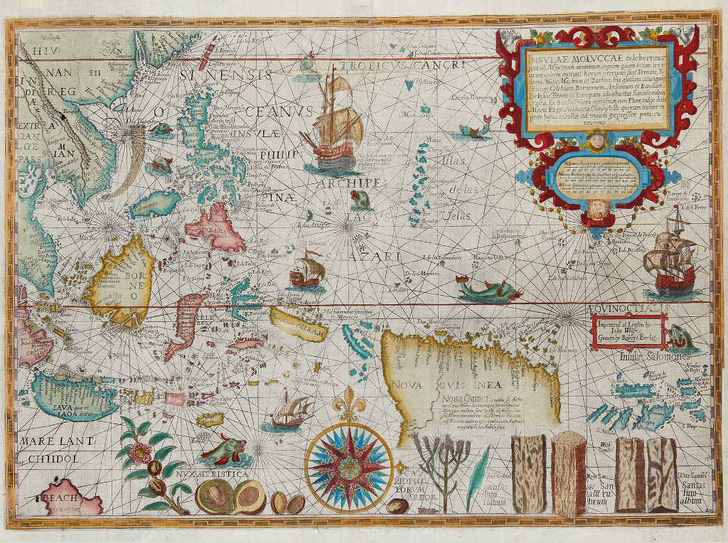
Petrus Plancius, "The Spice Map," double-page map of Southeast Asia, London, 1598. Sold December 8, 2016 for $31,200.
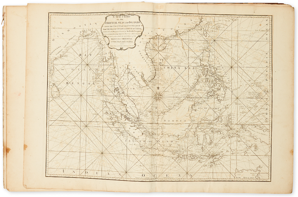
Robert Laurie & James Whittle, The Complete East-India Pilot, or Oriental Navigator, with 113 maps, London, 1797. Sold December 8, 2016 for $81,250.
*ALL PRICES INCLUDE BUYER’S PREMIUM
ILLUSTRATED CATALOGUE, DIGITAL IMAGES & COMPLETE PRICES REALIZED ON REQUEST
Alexandra Nelson
Communications Director
Swann Auction Galleries
104 East 25th St.
New York, NY 10010
(212) 254-4710 ext. 19
People in this conversation
 yanyan314 yanyan314
 Comments (105)
-
Guest - Taniya sharma
PermalinkSuperbly written article, if only all bloggers offered the same content as you, the internet would be a far better place.
https://www.kavya-arora.in/jodhpur-escorts.html0 Like -
Guest - shivani rawat
PermalinkI am glad to see this informative blog this article was made my day thanks for sharing this brilliant article with us, keep it up. Delhi Escorts Service
0 Like -
You can book escort in Nainital young ladies of your decisions relying upon your spending plans 24*7 any time. There are enormous assortments of flawless young call girls in Nainital accessible for cook your elite escort service in Nainital at uncommon rates. Everything you can get superb Nainital escort service to have female escorts who are offering astonishing physical closeness.
Udaipur escort service
Call girls service in Nainital
Haldwani escort service
Ramnagar escort service
Rudrapur escort service0 Like -
-
Though It is not relevant to me but it is quite informative and many of my connections relate to it.
0 Like -
The Girls here are hot and sexy and will give you all sorts of sexual fun and enjoyment here.
https://www.escortsingoa.net/0 Like -

Informative post. I never seen this type of article before keep sharing.
Bangalore Escorts
Escorts in Bangalore
Bangalore Call Girls
Call Girls in Bangalore
Escorts Services in Bangalore0 Like -
Guest - Saloni Rani
PermalinkOne of the key functions of Independent [URL=http://poojaescorts.in/escort-service-in-gurugram.html]Gurgaon Escorts[/URL] is that they have got a friendly and close persona. We can assure you that all our women love meeting new people and interacting with their customers. Like guys, many girls have an active libido and revel in bodily intimacy. Having a task as a [URL=https://www.missdelhiescort.com/gurugram-escorts.html]Gurgaon Escorts[/URL] gives them the possibility to fulfill their sexual impulses and connect at different degrees with their clients. Having a source of earnings is a need for the general public. [URL=https://salonirani4u.wixsite.com/ankita-call-girls/post/gurgaon-escorts-entertaining-and-coloring-your-nights]Gurgaon Escorts[/URL] are not different! Escorting may be a money making career and may give financial stability and flexibility to girls of all social strata.
0 Like
Leave your comments
Login to post a comment
Post comment as a guest